
Travel Advisory: Due to an unprecedented wildfire risk, forest activities are paused in New Brunswick. Stay up to date on current conditions and closures by visiting the Fire Watch information page.

Search

Showing 1 to 25 of 224 results

Boom Road Nature Area, Atholville Marsh

Atholville
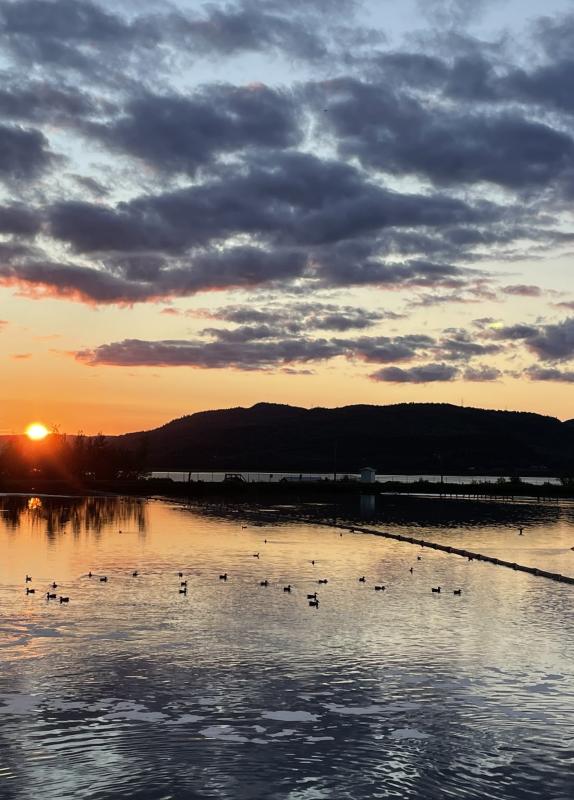
Located along Boom Road on the shore of the Restigouche River, this picturesque site, with salt marshes, lagoons, and wetlands, attracts a great diversity of birds year-round. Up to 25 species of ducks can be spotted in a single visit. In the spring, nearly 10,000 snow geese gather here, a rare sight in New Brunswick. Rest areas featuring shelters, benches, and picnic tables, make it an ideal spot to observe wildlife, enjoy beautiful river views or simply take in the peacefulness of nature.

Roads To Sea Tours

Moncton
Roads to Sea Guided Tours offers unforgettable, nature-based adventures led by founder and expert guide Anna-Marie Weir. Based in Moncton, N.B., we specialize in immersive, educational, and entertaining tours that showcase the ecological wonders of the region. We are known for our one-of-a-kind tour in the world to 'sea' high and low tide in the same day in the Bay of Fundy! Home of the world’s highest tides!

Bates Landing Roadside Market/U-Pick

Long Point
Bates Landing Roadside Market is located directly across from the Belleisle Bay Ferry Landing offering produce grown on our farm, local artisan products, scooped ice-cream, baking and conveniences. We also offer in-season u-pick fruit and vegetables (Apples, Strawberries, Raspberries, Vegetables, Pumpkins, Squash, Watermelon). Call ahead for U-Pick operating hours as they vary from the market hours.

South Oromocto River No. 2 Covered Bridge (Mill Settlement)

Mill Settlement West
Built in 1912, this covered bridge is 42 m (136 ft.) in length. Driving directions: Route 2, Exit 306, Route 7 South 8.5 km (5.2 mi.), Exit 29, Broad Road 1 km (0.6 mi.), turn left on Branch Road 16.2 km (10 mi.), Route 101 South 5.4 km (3.3 mi.), turn right on Mill Settlement Road 2.5 km (1.5 mi.), onto West Mill Settlement Road 200 m (218 yd.), at Mill Settlement West, near Hoyt.

Quisibis River No. 2 Covered Bridge

Sainte-Anne-de-Madawaska
Built in 1951, this covered bridge is 17 m (55 ft.) in length. The bridge is closed and no longer in use, but can be viewed from the road and from the new bridge crossing the same river beside it. Driving directions: Route 2, Exit 32, Davis Street North, turn right on Rivière-Quisibis Road 2.8 km (1.7 mi.), turn right on Lavoie Road 5.3 km (3.3 mi.), onto Deschênes Road.

Quaco Head Lighthouse

St. Martins
Every lighthouse you see has a special attraction all its own and the Quaco Head Lighthouse is no exception. It stands on a scenic point with an excellent view of St. Martins' beach and the Fundy Trail coastline. This 1855 tower was replaced in 1966 and altered a decade later with a concrete structure. It's the perfect spot for a picnic and birdwatching. The Quaco Museum has several lighthouse artifacts, including the Fresnel lens from the old structure. Driving directions: Route 111 to St. Martins, West Quaco Road, turn left on Lighthouse Road.

Cocagne Lighthouse (Front Range)

Cocagne
This 1907, original wooden salt-shaker tower is easy to find. It sits practically on the roadside of Route 134, adjacent to the Cocagne Bridge. Although the interior of the lighthouse is not open to the public, this is a great place to stop for a picnic, as tables are provided on site. There's also an excellent fish market just across the road, a gift shop next door and a jewellery shop nearby. The lighthouse is not active.

Royal View Maples

Royalton
We produce the finest 100% pure maple syrup and delicious 100% pure maple products. Maple operation is located 30 m (100 ft.) from paved road on Royalton Road, west of Florenceville-Bristol. Products available: maple syrup (in a wide variety of containers), maple butter, candy and sugar, sold year-round.